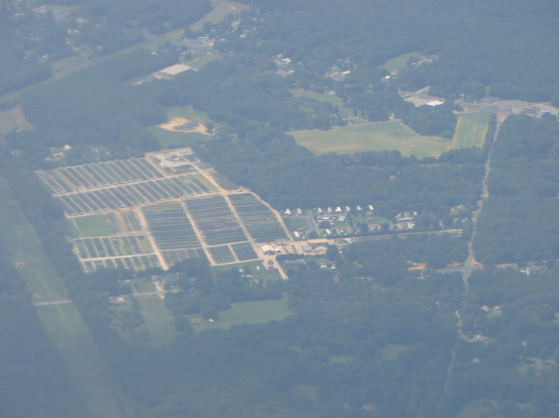
Aerial surveying is essential in land projects where large areas or unroaded terrains are involved. This is one of several general aviation areas Strategic Aviation Services (SAS) is passionate about. Assessing a site’s conditions to determine its features before embarking on a project has many benefits. Aerial surveys help avoid errors, save time, money, and ensure safety. In many African countries, where infrastructure deficits are huge, survey due diligence is vitally important – for new projects, maintenance, and conservation.
Poor planning and evaluation, inadequate documentation, surprise conditions and scope creep, often account for infrastructure and conservation failures. The sudden and total collapse of a fairly new structure in Bortianor, Greater Accra Region, and displacement of coastal communities in Keta, Volta Region—both in Ghana—typifies such failures. Indeed, lack of survey due diligence is far more costly than fees associated with the service. Notwithstanding the truth, it is common for decision makers to cut corners around this key element in project management.
In Bortianor, the entire structure of a mega church suddenly came down one afternoon – turning flat, to the utter shock of eyewitnesses. Torrential downpours and resulting erosion were blamed for the collapse. Deeper analysis however points to systemic failures in land development procedures in the entire district. This leaves many more properties in vulnerable states. In Keta, persistent coastal erosion, resulting from storm-related ocean surge, is blamed for the havoc. Obviously, the erosions only persisted in the absence of maintenance and intervention strategies. Geomatic services and shoreline control measures could have prevented the displacement of communities and destruction of commercial activities in the area.
As GIM International argues, keeping up with rapid urbanization and implementing sustainable infrastructure is not possible without reliable geospatial data, including faster mapping techniques. (Using Geospatial Data to Build Sustainable Cities, 2021). SAS maintains that surveys carried out from the air are more accurate, detailed and generate more complete results – compared to ground surveys. In any case, geospatial measurement of entire districts, to identify issues or risks that could impact land development or use, is an organizational responsibility. Government agencies, corporations and various other stakeholders—not individual property owners—bear the responsibility.
“In the United States, coastal erosion is responsible for roughly $500 million per year in property loss, including damage to structures and loss of land,” according to NOAA. The federal government keeps up by spending an average of $150 million yearly on beach nourishment and other erosion measures. In Africa, where conservation is in crisis, and governments face significant economic challenges, regional collaborations and partnerships with private organizations are especially important, to protect the natural world.
According to a study by Robson et al (2021), which sought to create a Conservation Area Performance Index, a staggering 82% of conservation in Savanna Africa was in a state of deterioration or failure. The survey, which measured budgets, management and threats pertaining to protected areas, found that only 10% of the 516 areas studied was in a state of success or recovery. That same year, Kavango Zambezi Transfrontier Conservation Area (KAZA) embarked on the first-ever concerted aerial count of Savanna elephants across Angola, Botswana, Namibia, Zambia and Zimbabwe.
The KAZA survey, funded by Paul G. Allen Family Foundation, in 2021, aimed to help guide conservation policies that promote healthy human elephant coexistence efforts. The results, which built on the foundation’s 2014-2016 Great Elephant Census, offered great hope. The KAZA region’s elephant population had a net gain of nearly a quarter million – with all participating countries, except Zambia, registering an increase in their elephant populations. In 2016, census results showed a 30% loss in elephant population across Africa.
Africa’s technology talent pool has a lot to offer in the continent’s productivity growth. Aerial surveying is just one area of General Aviation that plays a pivotal role. Consistency in mapping and monitoring the continent’s natural resources, infrastructure and land use can drive sustainable agriculture, urbanization, rural development and conservation. With Process Automation, Artificial Intelligence, Advanced Robotics and other cutting-edge technologies (including drones)—working alongside people—project management is streamlined and can only get better.
SAS is well positioned as a key resource in General Aviation. Its team of pilots and aviation specialists is open to working with various stakeholders, including governments and international organizations, to implement sustainable growth strategies. By providing efficient aerial surveys, where they are critically needed, using advanced technology, SAS helps guard the environment, ensure safe dwelling, and facilitates socioeconomic growth.


 Previous Post